Located along the southwest coast of Vancouver Island, the West Coast Trail (WCT) is called “the (backpacking) trip of a lifetime,” and it’s been on my hit list for over 20 years. Because of the relatively remote location, it is as much a project as a backpacking trip, and I was finally able to make it happen in mid-August with a great crew of old friends. Our shared verdict: It is a classic trek, truly worthy of the “trip of a lifetime” moniker.

The west coast of Vancouver Island was originally populated by the Pacheedaht, Ditidaht, Huu-ay-aht, and Nuu-chah-nulth First Nations peoples, and the current West Coast Trail is based on some of their trails. Europeans started arriving in the late 1700s, and as exploration, migration, and trade accelerated, the brutal weather and tidal conditions along Vancouver Island’s west coast resulted in increasing numbers of deadly shipwrecks. The area became known as the “Graveyard of the Pacific.” In January 1906 public outrage about the dangers reached a zenith when the SS Valencia wrecked, resulting in the deaths of 100 people. In response, the Canadian government built a rescue system including two lighthouses, a rough trail, and a telegraph line. That rescue trail was named the Dominion Lifesaving Trail, and later became the West Coast Trail. The West Coast Trail was incorporated into Pacific Rim National Park when it was established in the late 1960’s.

About the hike
The WCT is usually done as a point to point 75 km (~47 mi) adventure with terminus points at Pachena Bay (north) and Gordon River (south). Hikers are also allowed to enter or exit in the middle of the route at Nitinaht, which now provides an escape route and an option for a shorter 3-5 day hike.
The hike can be done in either direction, or as an out and back. The southern parts of the trail are considered to be more challenging than the trail in the north, although we didn’t think the differences were significant. There are challenges every kilometer of this amazing trek.

For some, it has a dangerous reputation.
The challenges include:
–Slippery conditions on muddy trails, boardwalks, boulders, and rocky shorelines. Unless you are walking on sand it’s best to assume you could slip at any time.
–Wading creeks and rivers
–Crossing rivers and ravines via hand-pulled cable cars
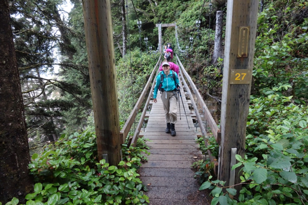
–Narrow, bouncy suspension bridges
–Damaged/rotting boardwalks, bridges, and ladders
–Climbing and descending steep slopes and earth slumps
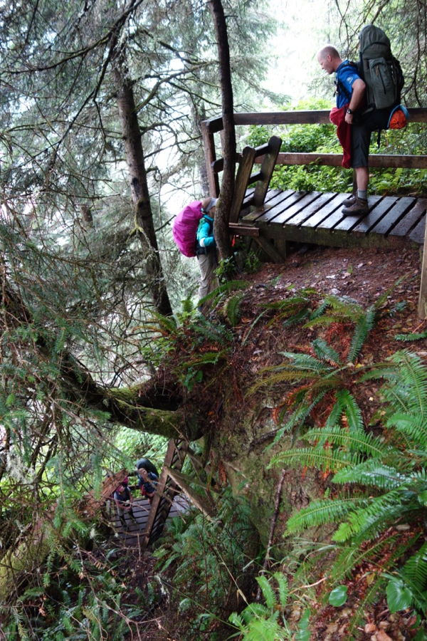
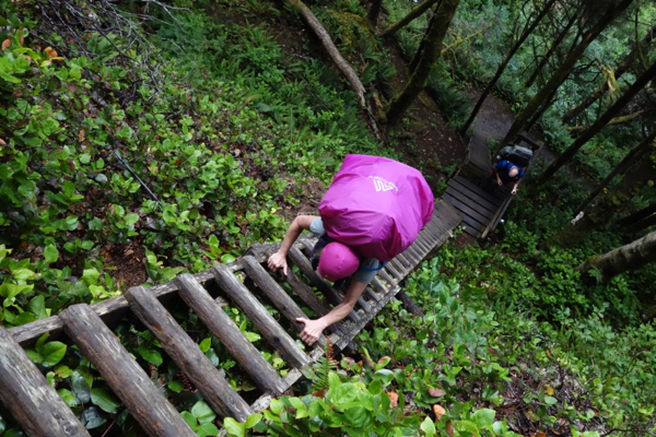
–Climbing and descending long wooden ladder systems
–Making route and campsite decisions based on the tides
The numbers of overnight hikers is controlled. Advance purchase is made via a lottery, and a few spots are saved for walk-ins.

Except for one location, camping is only permitted along the seashore. Designated camp sites include composting pit toilets and stainless steel food boxes. Although we noticed some folks camping outside of the official camp areas, pooping in the pit toilets during the busy months of July and August arguably reduces or at least localizes human impact. The stainless steel food boxes save the hassle of hanging food in trees. Rodents were a big problem and we heard stories of campers who lost food to them. We only observed one bear at the Pachena Bay campground who ambled out to the water’s edge to do mussel shooters during low tide.


Campfires are only permitted below the high tide line, but we noticed numerous fires and fire rings well above high tide.

Getting there and back
This was the “project” part of the trip. Our adventure was complicated by the fact that 2 of our crew were flying in from Northern California, and one from Southern California. After considering the options we decided on this travel plan, which is probably the “best” way to get there from the Seattle area:
Travel day 1:
–Take the Anacortes Ferry to Sydney
–Drive from Sydney to Gordon River (we arrived at about 10PM)
–Camp overnight at the Pacheedaht Campground
Travel day 2:
–Leave the cars at Gordon River ($30 CDN per car)
–Take the West Coast Trail Shuttle from Gordon River to Pachena Bay
–2PM mandatory orientation meeting at the trail headquarters
–Camp overnight at the Pachena Bay Campground
Travel day 9:
We weren’t exactly sure when we’d exit, especially if we had to wait out bad weather. So, we made multiple ferry reservations. We were able to get a cell signal on the next to last day at Camper Creek and cancel the reservations we didn’t use (although we are in a long queue with WA State Ferries to actually get the refunds). On the last day we had no problem hiking the strenuous 6km from Thrasher Cove to Gordon River and finish before noon. The drive from Gordon River to the Sydney ferry is a little over 2 hours.
Dining tip:
I can’t recommend any dining options at Pachena Bay, but the Coastal Kitchen Cafe in Port Renfrew had great pre- and post-hike options.
When to do it
The West Coast Trail is only open May 1 to September 30.
We decided mid-August would most likely have the driest weather.

Gear
In addition to a standard backpacking kit, here are a few recommendations for the WCT:
Rain gear:
You will get wet. Even when it’s not raining, the dense fog that typically forms after sunset condenses in the forest and there is a constant drip. Bring a tent with a rainfly (you will need it even on clear nights), rain jacket and pants, hat and gloves, and a rain cover for your pack.

Tarp:
Related to staying dry, bring a tarp, cord, and carabiners to set up a lean-to. This gives you a way to set up a dry place to hang out around the kitchen area. Some campers even put their tents under tarps.

Bear canister:
This was the first time I’d hiked using a bear canister, and I’m a convert. Although they weigh about 3 lbs, they save the hassles of being close to a food storage box and hanging a food bags. You can just leave them in camp. In addition, you can use them as stools when hanging out. We had a BearVault and a couple Garcias. Both brands are hard plastic cylinders. We also used them for water collection in a few locations. A lighter weight Spectra fabric option worth considering is the Ursack bag. The hard plastic option seems like it would be a better choice if you don’t want bears to smash your food.
Footwear:
Your feet will get wet. Wet feet easily blister. Blisters hurt. Everyone except me wore sturdy hiking boots with long gaiters. I went with La Sportiva Mutant trail running shoes and Smartwool running socks. I assumed that since my feet were going to get wet, I wanted footwear that would drain and dry quickly. I also planned to wear over-the-ankle scree gaiters, but didn’t get them set up properly prior to the hike, so I just hiked with the running shoes. They worked great for me–the sticky Italian rubber and aggressive tread pattern gripped like glue on almost every surface.
The one issue I had with the Mutants was that they were a bit short when my feet splayed out when loaded with a 50+ lb backpack. I had used them numerous times prior to the hike on trail runs and hikes and didn’t anticipate this issue. As a result I have one black toe.
One member of our party used neoprene socks and she loved them.
We had no major blister problems, but we also had a group of very experienced backpackers.

Trekking poles:
Trekking poles (or just some old ski poles) are a significant help in picking your way through the difficult terrain. Having four legs is better than two, and poles really help to maintain momentum and balance.
On the longer ladder sections I didn’t want them in my hands, and because I have an older pack I had to ask for help to attach and unattach them and get them out of the way. Newer packs have pole attachment systems that make it relatively easy to get them out of your hands.

The Hike
We did the hike from north to south over 7 days of hiking. The Parks Canada web site advises hikers be:
–Experienced in overnight backpacking
–Able to hike long distances through rough terrain with a full backpack
–Prepared to have a wilderness experience
–Able to wait if conditions warrant delays
–Over 12 years of age

In reality, we observed folks who did not appear to have adequate backpacking experience, and at least one child who was under 12. As we approached the finish, we heard from another hiker that there were three rescues the previous day. Even during a very dry August, the WCT lives up to its reputation.

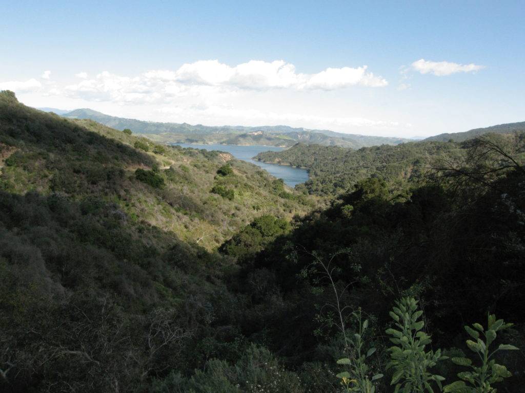
For most of the route hikers have the option to hike in the rain forest or along the seashore. The seashore is considered easier and to have fewer technical challenges. Some seashore sections are only passable at very low tides, so being able to interpret tide tables (provided by Parks Canada) and make route decisions based on the tides is a requirement.

In some places hiking along the seashore involves strenuous trudging through loose sand, in other sections the surface is flat rock and you can make good time. The section between the Owen Point cave (only accessible at low low tide) and the Thrasher campsite is a challenging/fun boulder hopping experience.

Accessing and leaving the seashore usually involves climbing and descending long, intimidating ladder systems. Ladder systems are located at many places in the forest, especially at creek and river crossings. Climbing the ladders can be quite strenuous: At the top of one particularly long ladder system a hiker was wearing a “Tough Mudder” shirt, and I asked how the WCT compared. Her answer: “This is WAY harder than any Tough Mudder.”
Hiking in the forest is a combination of trudging through mucky bogs, hurdling complicated root masses, doing single leg presses with a load, and walking on slippery and often disintegrating boardwalks and bridges. Most of the forest hiking involves climbing and descending steep muddy terrain. The forest sections are punctuated by spectacular vista points hacked out of the vegetation.

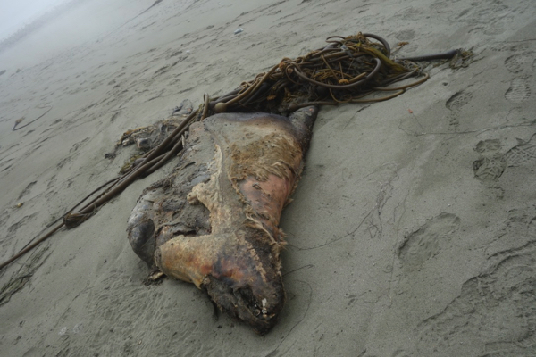
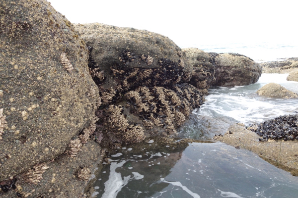
We didn’t see any whales, but did see bald eagles and a variety of seabirds, otters, sea lions a mink, intertidal invertebrates, giant kelp, and fungi. We also saw the decaying carcasses of a whale and a sea lion.


This year’s exceptionally dry weather resulted in low creek and river levels, and we only needed to do one (out of five total) cable car crossing. We were able to cross all of the other creeks on foot.

There is a required ferry crossing at the Nitinat river (the fee is included in the Parks Canada hiking fee). Coming from the north, you hang out for a while until the local ferry service stops by to pick you up. At the south side you can take a “real” food break and have some fresh crab or a fish sandwich and a beverage at Carl’s Crab Shack.

As you pass the 1/2 way point you encounter the renowned Chez Monique, which emanates the vibe of a tropical a beach bar outpost. Monique and a small crew of local teens serve (highly priced) burgers and liquid refreshments, and you can buy everything from toilet paper to Nanaimo bars. In this unlikely location, we had a table next to a group of northbound Seattle-area trail runners, one of whom I’d met at a Northwest Trail Run earlier in the year.

Although I think this kind of hike is all about enjoying amazing scenery and the company of good friends, it is also an obvious target for fastest known time (FKT) attempts:
Men
Record holder: Matt Cecill (Previous: Gary Robbins)
Date: July 19, 2014
Distance: 75 km
Time: 9h 32m 32s
Women
Record holder: Jen Segger (Previous: Jennie Sprigings)
Date: July 3, 2016
Distance: 75 km
Time: 13h 48m 09s

We planned and organized our hike using motion.social.